

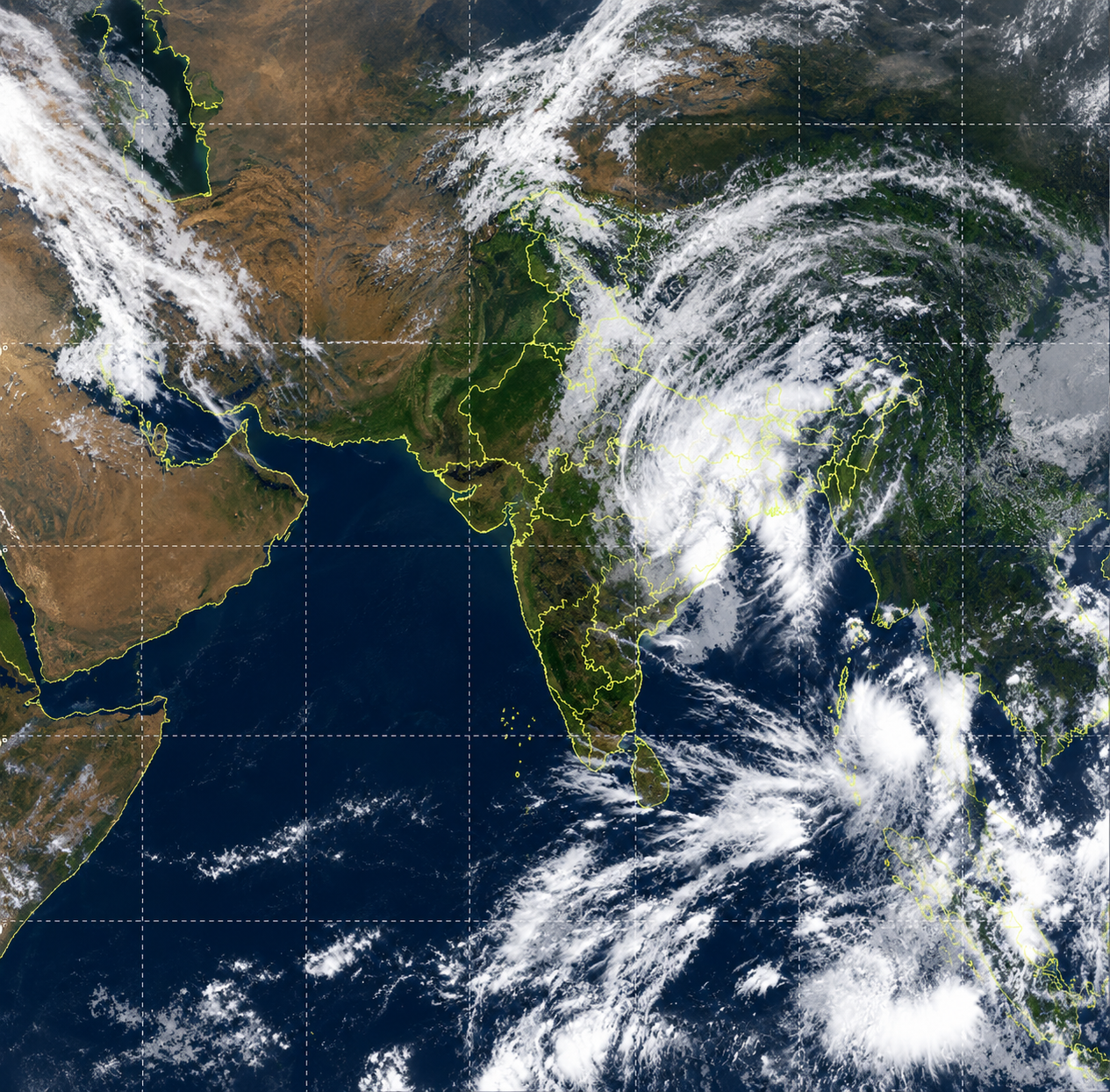
Satellite images have captured Cyclone Arnab’s enormous cloud shield spreading across several regions of India. The storm weakened after striking Andhra Pradesh, but its remaining clouds continue influencing weather across the country. Meteorologists warn that several states could experience heavy rainfall as the system moves further inland. The latest images reveal extensive cloud formations stretching from eastern India towards central and northern regions. These striking visuals demonstrate how cyclones can affect distant areas even after crossing coastal regions. Although Arnab has lost strength, its circulation continues transporting moisture and supporting widespread rainfall. Weather officials are monitoring the system closely to assess its movement and potential impacts. The storm’s weakening structure does not eliminate the possibility of dangerous weather conditions across affected states. Satellite observations provide valuable information about cloud movements and the cyclone’s remaining influence over India. Authorities continue tracking the system as rainfall threats persist across multiple regions.
Also read:Indian Developers to Present Projects at Moscow International Game Week
Satellite Images Reveal Cyclone Arnab’s Vast Cloud Cover Across India
The India Meteorological Department reported that Cyclone Arnab’s remnants weakened from a deep depression into a depression. Officials observed the weather system moving nearly northwards at approximately twenty-two kilometres per hour. At five-thirty on October twenty-ninth, the depression remained over southern Chhattisgarh and adjoining southern Odisha. Meteorologists placed its centre approximately twenty kilometres west of Jagdalpur in Chhattisgarh. The system also remained around two hundred ten kilometres southwest of Titlagarh in Odisha. Raipur, the Chhattisgarh capital, lay approximately two hundred fifty kilometres north of the depression’s centre. The department expects the system to continue travelling northwards while gradually losing its remaining strength. Forecasters predict that the depression will become a well-marked low-pressure area by October twenty-ninth evening. Doppler weather radars in Raipur and Sambalpur are tracking the system’s movement and development. These observations help meteorologists monitor changing conditions and issue timely warnings for vulnerable communities.
Satellite imagery reveals a sprawling cloud mass covering substantial portions of eastern and central India. The cloud formations extend northwards, demonstrating how the storm continues influencing distant regions after landfall. Bright cloud clusters indicate extensive cloud cover and areas where powerful atmospheric convection may develop. These formations can produce substantial rainfall as the cyclone’s remaining circulation transports moisture across inland regions. The storm’s effects therefore reach communities located far from the original coastal landfall location. Meteorologists examine satellite images to understand cloud distribution and anticipate potentially hazardous weather conditions. The imagery also reveals another cloud system developing over the Andaman Sea. This separate system relates to a low-pressure area over the eastern Indian Ocean. Scientists continue observing these developments to understand evolving atmospheric conditions across the surrounding region. Together, these satellite observations highlight India’s changing weather patterns during the cyclone’s inland journey.
Also read:Kochi Mercedes Crash: Victim’s Daughter Accuses Judge of Evidence Tampering
IMD Warns Several States of Heavy Rainfall as Cyclone Weakens
The India Meteorological Department has warned several states about possible heavy to very heavy rainfall. Northern districts of Chhattisgarh could experience intense rainfall at a few locations on October twenty-ninth. Jharkhand may also receive heavy to very heavy rainfall at isolated places during Thursday. Bihar faces similar rainfall risks on October twenty-ninth and October thirtieth, according to meteorological forecasts. Eastern Uttar Pradesh could experience heavy to very heavy rainfall on October twenty-ninth. Forecasters expect some parts of the state to maintain rainfall warnings during the following two days. Interior Odisha may also receive heavy rainfall as the system continues moving inland. Eastern Vidarbha and eastern Madhya Pradesh could experience significant rainfall during the same period. West Bengal also faces rainfall risks as the cyclone’s remnants influence regional weather conditions. Sub-Himalayan West Bengal and Sikkim could receive heavy rainfall on October twenty-ninth and thirtieth.
Despite Cyclone Arnab’s weakening intensity, meteorologists continue warning residents about potentially hazardous rainfall across affected regions. The system’s remaining circulation can transport moisture and sustain rainfall even after its centre loses strength. Heavy precipitation may disrupt transportation, affect daily activities, and create difficult conditions for vulnerable communities. Local authorities should monitor official weather bulletins and follow instructions issued by emergency management agencies. Residents in forecast areas should remain alert for updated rainfall warnings and possible local advisories. Satellite imagery helps forecasters identify cloud movements and evaluate the storm’s continuing influence over India. Weather radars provide additional information about the system’s location, movement, and associated precipitation patterns. These monitoring tools support timely forecasts and help authorities prepare for changing weather conditions. The cyclone’s inland movement demonstrates why communities must remain cautious even after coastal landfall. Officials will continue assessing the system as it weakens and moves towards a low-pressure area.
Also read:Delhi Man Stabbed to Death After Asking for Extra Chole